
Haarbach topographic map
Interactive map
Click on the map to display elevation.
About this map
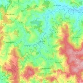
Name: Haarbach topographic map, elevation, terrain.
Location: Haarbach, Landkreis Passau, Beieren, 94542, Duitsland (48.46600 13.08498 48.53709 13.20233)
Average elevation: 425 m
Minimum elevation: 347 m
Maximum elevation: 535 m
Other topographic maps
Click on a map to view its topography, its elevation and its terrain.
Bad Füssing
Duitsland > Beieren > Landkreis Passau
Bad Füssing, Landkreis Passau, Beieren, 94072, Duitsland
Average elevation: 342 m
Donau
Duitsland > Beieren > Landkreis Passau > Riedl > Jochenstein
Donau, Jochenstein, Riedl, Untergriesbach, Landkreis Passau, Beieren, 94107, Duitsland
Average elevation: 454 m
Hundsruck
Duitsland > Beieren > Landkreis Passau > Untergriesbach > Hundsruck
Hundsruck, Untergriesbach, Landkreis Passau, Beieren, 94136, Duitsland
Average elevation: 448 m