
Thank you for supporting this site ❤️
Make a donation
Make a donation
Gear up for your next adventure:
As an Amazon Associate, this site earns from qualifying purchases at no extra cost to you.
Amboise topographic map
Click on the map to display elevation.
Thank you for supporting this site ❤️
Make a donation
Make a donation
Gear up for your next adventure:
As an Amazon Associate, this site earns from qualifying purchases at no extra cost to you.
About this map
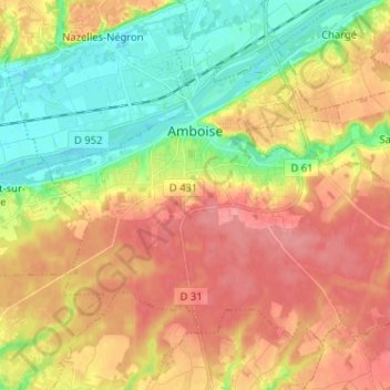
Name: Amboise topographic map, elevation, terrain.
Average elevation: 91 m
Minimum elevation: 50 m
Maximum elevation: 130 m
Thank you for supporting this site ❤️
Make a donation
Make a donation
Gear up for your next adventure:
As an Amazon Associate, this site earns from qualifying purchases at no extra cost to you.
Other topographic maps
Click on a map to view its topography, its elevation and its terrain.
Basse-Bretagne
France > Centre-Val de Loire > Indre-et-Loire > Château-la-Vallière
Average elevation: 89 m
La Patte au Loup
France > Centre-Val de Loire > Indre-et-Loire > Chouzé-sur-Loire
Average elevation: 31 m