Geolocate

Lenoir topographic map

Click on the map to display elevation.

About this map

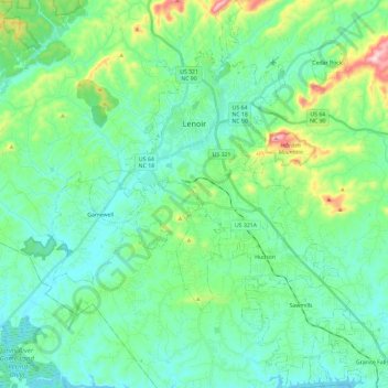
Name: Lenoir topographic map, elevation, terrain.

Location: Lenoir, Caldwell County, North Carolina, United States (35.78379 -81.59380 35.97491 -81.46398)

Average elevation: 381 m

Minimum elevation: 300 m

Maximum elevation: 683 m

Gear up for your next adventure:

🏃Compression Recovery Socks - Reduce leg fatigue after heavy days of elevation gain
🦯Trekking Poles - Walking poles for hiking stability
🕯️Emergency Whistles - Safety whistles for hiking
🌧️Rain Jackets - Waterproof jackets for hiking
🧰Survival Kits - Essential survival gear

As an Amazon Associate, this site earns from qualifying purchases at no extra cost to you.