
Hoëgne topographic map
Interactive map
Click on the map to display elevation.
About this map
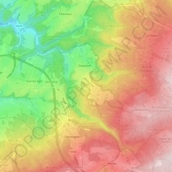
Name: Hoëgne topographic map, elevation, terrain.
Location: Hoëgne, Jalhay, Verviers, Luik, Wallonië, 4845, België (50.48821 5.91786 50.54239 6.03435)
Average elevation: 445 m
Minimum elevation: 247 m
Maximum elevation: 618 m
De Hoëgne ontspringt op de hoogte van Mont Rigi in Sourbrodt, een deelgemeente van Weismes. Het riviertje draagt er de naam Rû de Polleur en neemt na een vijftal kilometer de Rû de Herbofaye op, die ontspringt in de buurt van de Baraque Michel.