Geolocate

Springe topographic map

Click on the map to display elevation.

About this map
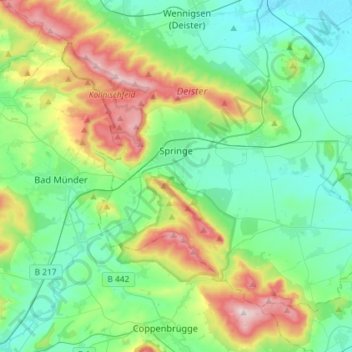
Name: Springe topographic map, elevation, terrain.

Location: Springe, Region Hannover, Lower Saxony, 31832, Germany (52.12836 9.46406 52.26541 9.75358)

Average elevation: 160 m

Minimum elevation: 65 m

Maximum elevation: 416 m

Other topographic maps

Click on a map to view its topography, its elevation and its terrain.

Hexenturm

Germany > Lower Saxony > Region Hannover > Hanover

Average elevation: 51 m

Resse

Germany > Lower Saxony > Region Hannover

Average elevation: 48 m

Kirchhorst

Germany > Lower Saxony > Region Hannover

Average elevation: 60 m

Scherenbostel

Germany > Lower Saxony > Region Hannover

Average elevation: 60 m

Dachtmissen

Germany > Lower Saxony > Region Hannover > Burgdorf

Average elevation: 53 m

Liethe

Germany > Lower Saxony > Region Hannover > Wunstorf

Average elevation: 46 m

Altwarmbüchen

Germany > Lower Saxony > Region Hannover

Average elevation: 57 m

Gear up for your next adventure:

⛺Ultralight Solo Tents - Compact shelters for multi-day topographic surveying expeditions
🌧️Rain Jackets - Waterproof jackets for hiking
🔦Headlamps - Hands-free lighting for hiking
🔑Heavy Duty Carabiners - Secure gear to the outside of your pack for easy access
🧢Wide Brim Sun Hats - Maximum coverage for the face and neck while out in the open

As an Amazon Associate, this site earns from qualifying purchases at no extra cost to you.