
Make a donation
Gear up for your next adventure:
As an Amazon Associate, this site earns from qualifying purchases at no extra cost to you.
Hildenborough topographic map
Click on the map to display elevation.
Make a donation
Gear up for your next adventure:
As an Amazon Associate, this site earns from qualifying purchases at no extra cost to you.
About this map
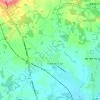
Name: Hildenborough topographic map, elevation, terrain.
Average elevation: 54 m
Minimum elevation: 19 m
Maximum elevation: 165 m
Make a donation
Gear up for your next adventure:
As an Amazon Associate, this site earns from qualifying purchases at no extra cost to you.
Other topographic maps
Click on a map to view its topography, its elevation and its terrain.
Ightham Common
United Kingdom > England > Kent > Tonbridge and Malling > Ightham
Average elevation: 145 m
Make a donation
Gear up for your next adventure:
As an Amazon Associate, this site earns from qualifying purchases at no extra cost to you.
Barden Lake
United Kingdom > England > Kent > Tonbridge and Malling > Tonbridge
Average elevation: 33 m
Holborough Lakes
United Kingdom > England > Kent > Tonbridge and Malling > Snodland
Average elevation: 32 m
Make a donation
Gear up for your next adventure:
As an Amazon Associate, this site earns from qualifying purchases at no extra cost to you.
Beltring
United Kingdom > England > Kent > Tonbridge and Malling > East Peckham
Average elevation: 15 m
Kit's Coty
United Kingdom > England > Kent > Tonbridge and Malling > Bluebell Hill
Average elevation: 102 m
Make a donation
Gear up for your next adventure:
As an Amazon Associate, this site earns from qualifying purchases at no extra cost to you.
Royal British Legion Village
United Kingdom > England > Kent > Tonbridge and Malling
Average elevation: 33 m
Pratling Street
United Kingdom > England > Kent > Tonbridge and Malling > Aylesford > Pratling Street
Average elevation: 49 m
Bradbourne
United Kingdom > England > Kent > Tonbridge and Malling > East Malling
Average elevation: 28 m
Make a donation
Gear up for your next adventure:
As an Amazon Associate, this site earns from qualifying purchases at no extra cost to you.
Make a donation
Gear up for your next adventure:
As an Amazon Associate, this site earns from qualifying purchases at no extra cost to you.