
St Donats topographic map
Interactive map
Click on the map to display elevation.
About this map
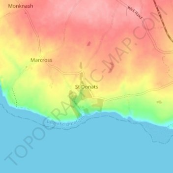
Name: St Donats topographic map, elevation, terrain.
Location: St Donats, Vale of Glamorgan, Wales, CF61 1ZA, United Kingdom (51.38592 -3.55050 51.42592 -3.51050)
Average elevation: 43 m
Minimum elevation: 0 m
Maximum elevation: 94 m
Other topographic maps
Click on a map to view its topography, its elevation and its terrain.
Dyffryn
United Kingdom > Wales > Vale of Glamorgan
Dyffryn, Vale of Glamorgan, Wales, CF5 6SW, United Kingdom
Average elevation: 73 m
Barry
United Kingdom > Wales > Vale of Glamorgan
Barry, Vale of Glamorgan, Wales, United Kingdom
Average elevation: 29 m