
Make a donation
Gear up for your next adventure:
As an Amazon Associate, this site earns from qualifying purchases at no extra cost to you.
Hutchinson topographic map
Click on the map to display elevation.
Make a donation
Gear up for your next adventure:
As an Amazon Associate, this site earns from qualifying purchases at no extra cost to you.
Hutchinson
Hutchinson is located at 38°3′39″N 97°55′47″W / 38.06083°N 97.92972°W / 38.06083; -97.92972 (38.0608445, -97.9297743) at an elevation of 1,535 feet (468 m). Located in south-central Kansas at the intersection of U.S. Route 50 and Kansas Highway 96 (K-96), Hutchinson is 39 miles (63 km) northwest of Wichita, 200 mi (320 km) west-southwest of Kansas City, and 395 miles (636 km) east-southeast of Denver.
Make a donation
Gear up for your next adventure:
As an Amazon Associate, this site earns from qualifying purchases at no extra cost to you.
About this map
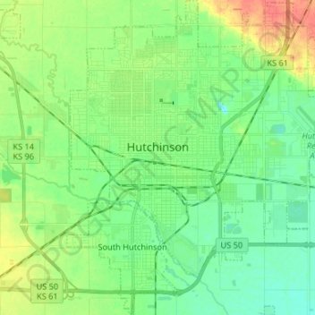
Name: Hutchinson topographic map, elevation, terrain.
Location: Hutchinson, Reno County, Kansas, United States (38.00554 -97.96632 38.10895 -97.84613)
Average elevation: 471 m
Minimum elevation: 455 m
Maximum elevation: 502 m
Make a donation
Gear up for your next adventure:
As an Amazon Associate, this site earns from qualifying purchases at no extra cost to you.