
Ad Dakhiliyah Governorate topographic map
Interactive map
Click on the map to display elevation.
About this map
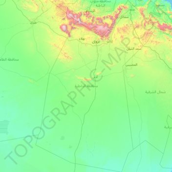
Name: Ad Dakhiliyah Governorate topographic map, elevation, terrain.
Location: Ad Dakhiliyah Governorate, Oman (20.90857 56.52715 23.55060 58.52517)
Average elevation: 315 m
Minimum elevation: 0 m
Maximum elevation: 2,943 m
Other topographic maps
Click on a map to view its topography, its elevation and its terrain.
Nakhal
Oman > Al Batinah South Governorate
Nakhal, Al Batinah South Governorate, Oman
Average elevation: 457 m
Al Buraymi Governorate
Al Buraymi Governorate, Oman
Average elevation: 320 m
Al-Musannah
Oman > Al Batinah South Governorate > Al-Musannah
Al-Musannah, Al Batinah South Governorate, Oman
Average elevation: 28 m
Al Qashar
Oman > Al Batinah South Governorate > Al Qashar
Al Qashar, al-Dschabal al-Achdar, Al Batinah South Governorate, 621, Oman
Average elevation: 1,902 m
al Awabi
Oman > Al Batinah South Governorate > al Awabi
al Awabi, Al Batinah South Governorate, Oman
Average elevation: 735 m
Al Hajar Mountains
Oman > Al Batinah South > Ar Rustaq
Al Hajar Mountains, Ar Rustaq, Al Batinah South, Oman
Average elevation: 2,502 m