
Make a donation
Gear up for your next adventure:
As an Amazon Associate, this site earns from qualifying purchases at no extra cost to you.
Bokod topographic map
Click on the map to display elevation.
Make a donation
Gear up for your next adventure:
As an Amazon Associate, this site earns from qualifying purchases at no extra cost to you.
About this map
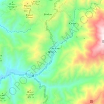
Name: Bokod topographic map, elevation, terrain.
Average elevation: 1,244 m
Minimum elevation: 769 m
Maximum elevation: 2,167 m
Make a donation
Gear up for your next adventure:
As an Amazon Associate, this site earns from qualifying purchases at no extra cost to you.
Other topographic maps
Click on a map to view its topography, its elevation and its terrain.
La Trinidad
The terrain is generally mountainous with springs, rivers and creeks. The town has a valley which encompasses several barangays. The valley floor elevation is at 1,300 metres (4,300 ft) above sea level. Elevation ranges from 500 to 1,700 metres (1,600 to 5,600 ft) above sea level.
Average elevation: 1,123 m
Make a donation
Gear up for your next adventure:
As an Amazon Associate, this site earns from qualifying purchases at no extra cost to you.
Make a donation
Gear up for your next adventure:
As an Amazon Associate, this site earns from qualifying purchases at no extra cost to you.
Make a donation
Gear up for your next adventure:
As an Amazon Associate, this site earns from qualifying purchases at no extra cost to you.
Wangal, La Trinidad, Benguet
Philippines > Benguet > La Trinidad > Wangal > Ampasit
Average elevation: 1,352 m
La Trinidad
The terrain is generally mountainous with springs, rivers and creeks. The town has a valley which encompasses several barangays. The valley floor elevation is at 1,300 metres (4,300 ft) above sea level. Elevation ranges from 500 to 1,700 metres (1,600 to 5,600 ft) above sea level.
Average elevation: 1,123 m
Make a donation
Gear up for your next adventure:
As an Amazon Associate, this site earns from qualifying purchases at no extra cost to you.
Ambuklao Dam
Philippines > Benguet > Ambuclao > Ambangol
SNAP-Benguet began a massive rehabilitation project that restored Ambuklao to operating status and increased its capacity from 75 MW to 105 MW. The project required the construction of a new intake, headrace and penstock, elevation of tailrace tunnel outlet, de-silting of tailrace tunnel and replacement of…
Average elevation: 808 m