
Cattaraugus County topographic map
Interactive map
Click on the map to display elevation.
About this map
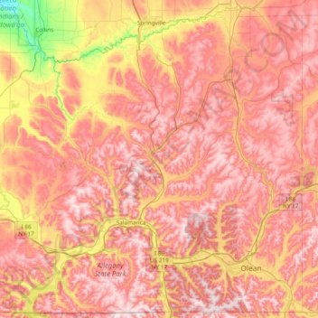
Name: Cattaraugus County topographic map, elevation, terrain.
Location: Cattaraugus County, New York, Verenigde Staten van Amerika (41.99746 -79.06135 42.54035 -78.30714)
Average elevation: 519 m
Minimum elevation: 190 m
Maximum elevation: 736 m
Other topographic maps
Click on a map to view its topography, its elevation and its terrain.
New York County
Verenigde Staten van Amerika > New York > NYC
Manhattan, New York County, NYC, New York, Verenigde Staten van Amerika
Average elevation: 17 m
Boutonville
Verenigde Staten van Amerika > New York > Town of Pound Ridge > Pound Ridge > Boutonville
Boutonville, Pound Ridge, Town of Pound Ridge, Westchester County, New York, 10590, Verenigde Staten van Amerika
Average elevation: 174 m