Geolocate

Oamaru topographic map

Click on the map to display elevation.

About this map

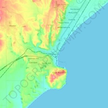
Name: Oamaru topographic map, elevation, terrain.

Location: Oamaru, Waitaki District, Otago, 9444, New Zealand (-45.13977 170.92842 -45.05977 171.00842)

Average elevation: 34 m

Minimum elevation: 0 m

Maximum elevation: 140 m

Gear up for your next adventure:

🎽Hiking Clothing - Breathable clothing for hiking
🧦Merino Wool Hiking Socks - Moisture-wicking socks to prevent blisters during long topographic surveys
🐍Snake Gaiters - Protection against snake bites
🔦Headlamps - Hands-free lighting for hiking
🔥Windproof Plasma Lighters - USB rechargeable lighters that work in high-altitude winds

As an Amazon Associate, this site earns from qualifying purchases at no extra cost to you.