
Make a donation
Gear up for your next adventure:
As an Amazon Associate, this site earns from qualifying purchases at no extra cost to you.
Oregon City topographic map
Click on the map to display elevation.
Make a donation
Gear up for your next adventure:
As an Amazon Associate, this site earns from qualifying purchases at no extra cost to you.
About this map
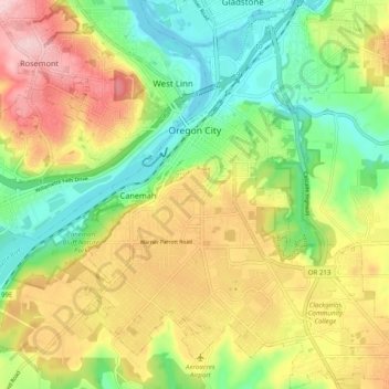
Name: Oregon City topographic map, elevation, terrain.
Average elevation: 99 m
Minimum elevation: -1 m
Maximum elevation: 227 m
Make a donation
Gear up for your next adventure:
As an Amazon Associate, this site earns from qualifying purchases at no extra cost to you.
Other topographic maps
Click on a map to view its topography, its elevation and its terrain.
Mount Talbert
United States > Oregon > Clackamas County > Happy Valley
Mount Talbert is a volcanic cinder cone in Clackamas County, Oregon. It is part of the Boring Lava Field, a zone of ancient volcanic activity in the area around Portland. Its summit rises to an elevation of 740+ ft (230+ m).
Average elevation: 96 m
Make a donation
Gear up for your next adventure:
As an Amazon Associate, this site earns from qualifying purchases at no extra cost to you.
Boring
United States > Oregon > Clackamas County
Boring's landscape is hilly, with its elevation ranging between 548 feet (167 m) and 755 feet (230 m). Several creeks run west through the community limits into the Clackamas River, including Doane Creek, North Fork Deep Creek, and Tickle Creek.
Average elevation: 182 m
Make a donation
Gear up for your next adventure:
As an Amazon Associate, this site earns from qualifying purchases at no extra cost to you.
Make a donation
Gear up for your next adventure:
As an Amazon Associate, this site earns from qualifying purchases at no extra cost to you.
Bagby Hot Springs
United States > Oregon > Clackamas County
Bagby Hot Springs are natural hot springs in the Mount Hood National Forest, about 67 miles (108 km) southeast of Portland, Oregon, United States and about 98 miles (158 km) east of Salem, Oregon. The springs are in the Cascade Mountains in a heavily forested area at elevation 2280 ft (695 m). They are just…
Average elevation: 880 m
Mount Talbert
United States > Oregon > Clackamas County > Happy Valley
Mount Talbert is a volcanic cinder cone in Clackamas County, Oregon. It is part of the Boring Lava Field, a zone of ancient volcanic activity in the area around Portland. Its summit rises to an elevation of 740+ ft (230+ m).
Average elevation: 96 m
Make a donation
Gear up for your next adventure:
As an Amazon Associate, this site earns from qualifying purchases at no extra cost to you.
Make a donation
Gear up for your next adventure:
As an Amazon Associate, this site earns from qualifying purchases at no extra cost to you.
Make a donation
Gear up for your next adventure:
As an Amazon Associate, this site earns from qualifying purchases at no extra cost to you.
Make a donation
Gear up for your next adventure:
As an Amazon Associate, this site earns from qualifying purchases at no extra cost to you.