
Make a donation
Gear up for your next adventure:
As an Amazon Associate, this site earns from qualifying purchases at no extra cost to you.
Kirkwood topographic map
Click on the map to display elevation.
Make a donation
Gear up for your next adventure:
As an Amazon Associate, this site earns from qualifying purchases at no extra cost to you.
About this map
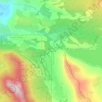
Name: Kirkwood topographic map, elevation, terrain.
Average elevation: 2,432 m
Minimum elevation: 2,145 m
Maximum elevation: 2,816 m
Make a donation
Gear up for your next adventure:
As an Amazon Associate, this site earns from qualifying purchases at no extra cost to you.
Other topographic maps
Click on a map to view its topography, its elevation and its terrain.
Eldorado National Forest
United States > California > El Dorado County
The forest ranges in elevation from 1,000 feet (300 m) in the foothills to more than 10,000 feet (3,000 m) above sea level along the Sierra crest. The mountainous topography is broken by the steep canyons of the Mokelumne, Cosumnes, American, and Rubicon rivers. Plateaus of generally moderate relief are…
Average elevation: 1,807 m
Fallen Leaf Lake
United States > California > El Dorado County
The surface elevation of the lake is 152 feet (46 m) above Lake Tahoe.
Average elevation: 2,068 m
Lake Tahoe Basin Management Unit
United States > California > El Dorado County
The Lake Tahoe Basin Management Unit is a United States National Forest that manages and protects public land surrounding Lake Tahoe and the Lake Tahoe Basin. Straddling the state borders of California and Nevada in the Sierra Nevada, the LTBMU encompasses 154,851 acres (626 km²) of National Forest system…
Average elevation: 1,981 m
Make a donation
Gear up for your next adventure:
As an Amazon Associate, this site earns from qualifying purchases at no extra cost to you.
Diamond Springs
United States > California > El Dorado County
Diamond Springs (formerly, Diamond Spring and Diamond) is a census-designated place (CDP) in El Dorado County, California, United States. It is part of the Sacramento–Arden-Arcade–Roseville Metropolitan Statistical Area. The population was 11,037 at the 2010 census, up from 4,888 at the 2000 census. The…
Average elevation: 531 m
Make a donation
Gear up for your next adventure:
As an Amazon Associate, this site earns from qualifying purchases at no extra cost to you.
Laurel Oaks Park
United States > California > El Dorado County > Cameron Park > Bar J Ranch
Average elevation: 380 m
South Lake Tahoe-El Dorado Recreation Area
United States > California > El Dorado County > South Lake Tahoe > Bijou
Average elevation: 1,905 m
El Dorado Hills
United States > California > El Dorado County > Folsom
El Dorado Hills (EDH), as defined by the 2010 census-designated place (CDP), is at the western border of El Dorado County, between the City of Folsom and the unincorporated community of Cameron Park. The northern limits of the CDP are Folsom Lake and the South Fork of the American River, where river rafters…
Average elevation: 243 m
Make a donation
Gear up for your next adventure:
As an Amazon Associate, this site earns from qualifying purchases at no extra cost to you.