Geolocate

Macabud topographic map

Click on the map to display elevation.

About this map
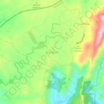
Name: Macabud topographic map, elevation, terrain.

Location: Macabud, Montalban, Rizal, Calabarzon, 1860, Philippines (14.77762 121.11953 14.81762 121.15953)

Average elevation: 225 m

Minimum elevation: 75 m

Maximum elevation: 440 m

Other topographic maps

Click on a map to view its topography, its elevation and its terrain.
Wawa Dam

Philippines > Rizal > Montalban > Wawa > Inigan

Average elevation: 156 m

Upper Wawa Dam

Philippines > Rizal > Montalban

Average elevation: 186 m

Gear up for your next adventure:

🪑Portable Backpacking Chairs - A comfortable seat for studying maps at the end of the day
🧥Insulated Down Jackets - High warmth-to-weight ratio for cold nights in the high country
🛌Sleeping Mats - Insulated mats for camping comfort
📡Portable Emergency Radios - Stay informed about weather warnings and bushfire alerts
🧴Sunscreen SPF - Sun protection for outdoor activities

As an Amazon Associate, this site earns from qualifying purchases at no extra cost to you.