
Thank you for supporting this site ❤️
Make a donation
Make a donation
Gear up for your next adventure:
As an Amazon Associate, this site earns from qualifying purchases at no extra cost to you.
Peterton topographic map
Click on the map to display elevation.
Thank you for supporting this site ❤️
Make a donation
Make a donation
Gear up for your next adventure:
As an Amazon Associate, this site earns from qualifying purchases at no extra cost to you.
About this map
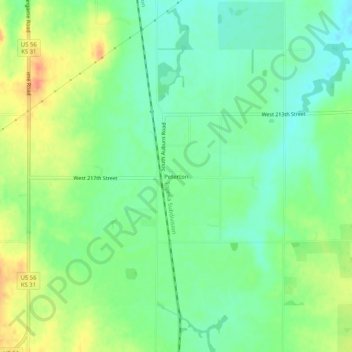
Name: Peterton topographic map, elevation, terrain.
Location: Peterton, Osage County, Kansas, 66523, United States (38.65362 -95.83693 38.69362 -95.79693)
Average elevation: 330 m
Minimum elevation: 312 m
Maximum elevation: 355 m
Thank you for supporting this site ❤️
Make a donation
Make a donation
Gear up for your next adventure:
As an Amazon Associate, this site earns from qualifying purchases at no extra cost to you.
Other topographic maps
Click on a map to view its topography, its elevation and its terrain.
Thank you for supporting this site ❤️
Make a donation
Make a donation
Gear up for your next adventure:
📣High-Decibel Survival Whistles - Signaling tool for rescue that carries much further than a human voice
As an Amazon Associate, this site earns from qualifying purchases at no extra cost to you.