
Thank you for supporting this site ❤️
Make a donation
Make a donation
Gear up for your next adventure:
As an Amazon Associate, this site earns from qualifying purchases at no extra cost to you.
Paklenica topographic map
Click on the map to display elevation.
Thank you for supporting this site ❤️
Make a donation
Make a donation
Gear up for your next adventure:
As an Amazon Associate, this site earns from qualifying purchases at no extra cost to you.
About this map
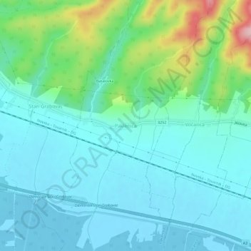
Name: Paklenica topographic map, elevation, terrain.
Location: Paklenica, Grad Novska, Sisak-Moslavina County, 44330, Croatia (45.29985 17.00441 45.33985 17.04441)
Average elevation: 133 m
Minimum elevation: 91 m
Maximum elevation: 290 m
Thank you for supporting this site ❤️
Make a donation
Make a donation
Gear up for your next adventure:
As an Amazon Associate, this site earns from qualifying purchases at no extra cost to you.