Geolocate

Heber topographic map

Click on the map to display elevation.

About this map

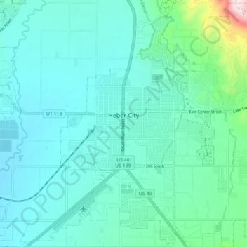
Name: Heber topographic map, elevation, terrain.

Location: Heber, Wasatch County, Utah, 84032, United States (40.47148 -111.44473 40.53675 -111.35712)

Average elevation: 1,737 m

Minimum elevation: 1,662 m

Maximum elevation: 2,170 m

Other topographic maps

Click on a map to view its topography, its elevation and its terrain.

Soldier Summit

United States > Utah > Wasatch County

Average elevation: 2,323 m

Heber City

United States > Utah > Wasatch County

Average elevation: 1,758 m

Gear up for your next adventure:

🧭Global Orienteering Compass - High-precision liquid-filled compasses for accurate map reading and navigation
💡Collapsible Camping Lanterns - Illuminate your base camp or tent for map studying at night
📱Tablet Tripod Mounts - Steady platforms for viewing digital maps or taking long exposures
🔋Rechargeable Batteries - Eco-friendly power for high-drain GPS units and flashlights
🩹First Aid Kits - Emergency kits for hiking

As an Amazon Associate, this site earns from qualifying purchases at no extra cost to you.