
Make a donation
Gear up for your next adventure:
As an Amazon Associate, this site earns from qualifying purchases at no extra cost to you.
Kelowna topographic map
Click on the map to display elevation.
Make a donation
Gear up for your next adventure:
As an Amazon Associate, this site earns from qualifying purchases at no extra cost to you.
Kelowna
Kelowna is classified as a humid continental climate or an inland oceanic climate per the Köppen climate classification system due to its coldest month having an average temperature slightly above −3.0 °C (26.6 °F) and below 0 °C (32 °F), with dry, hot, sunny summers and cool, cloudy winters, and four seasons. The official climate station for Kelowna is at the Kelowna International Airport, which is at a higher elevation than the city core, with slightly higher precipitation and cooler nighttime temperatures. Kelowna has the second mildest winter of any non-coastal city in Canada, after neighbouring Penticton. This is caused by the moderating effects of Okanagan Lake combined with mountains separating most of BC from the prairies; however bitter Arctic air masses can occasionally penetrate the valley during winter, usually for very short periods. The coldest recorded temperature in the city was −36.1 °C (−33.0 °F) recorded on December 30, 1968. The last time the lake completely froze over was in the winter of 1969.A partial lake freeze also took place in the winter of 1985–1986. Some winters pass without any significant surface ice.
Make a donation
Gear up for your next adventure:
As an Amazon Associate, this site earns from qualifying purchases at no extra cost to you.
About this map
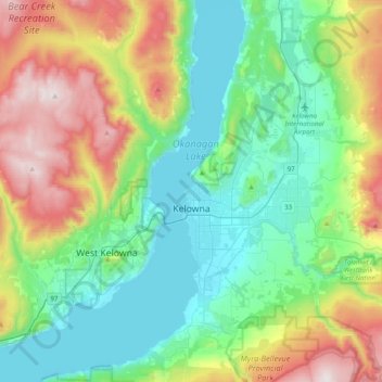
Name: Kelowna topographic map, elevation, terrain.
Average elevation: 704 m
Minimum elevation: 335 m
Maximum elevation: 1,576 m
Make a donation
Gear up for your next adventure:
As an Amazon Associate, this site earns from qualifying purchases at no extra cost to you.
Other topographic maps
Click on a map to view its topography, its elevation and its terrain.
Mission Creek Regional Park
Canada > British Columbia > Regional District of Central Okanagan > Kelowna
Average elevation: 436 m
The Commons Field
Canada > British Columbia > Regional District of Central Okanagan > Kelowna
Average elevation: 442 m
Fintry
Canada > British Columbia > Regional District of Central Okanagan > West Central Okanagan Electoral Area
Average elevation: 437 m
Pandosy
Canada > British Columbia > Regional District of Central Okanagan > Kelowna
Average elevation: 345 m
Make a donation
Gear up for your next adventure:
As an Amazon Associate, this site earns from qualifying purchases at no extra cost to you.
Terrace Mountain
Canada > British Columbia > Regional District of Central Okanagan > West Central Okanagan Electoral Area
Average elevation: 1,553 m
Oyama
Canada > British Columbia > Regional District of Central Okanagan > Lake Country
Average elevation: 481 m
West Kelowna
Canada > British Columbia > Regional District of Central Okanagan > West Kelowna
Average elevation: 871 m
Damer Lake
Canada > British Columbia > Regional District of Central Okanagan > East Central Okanagan Electoral Area
Average elevation: 1,353 m
Make a donation
Gear up for your next adventure:
As an Amazon Associate, this site earns from qualifying purchases at no extra cost to you.
Browne Lake
Canada > British Columbia > Regional District of Central Okanagan > East Central Okanagan Electoral Area
Average elevation: 1,326 m
Christie Lake
Canada > British Columbia > Regional District of Central Okanagan > West Central Okanagan Electoral Area
Average elevation: 1,448 m
Little White Mountain
Canada > British Columbia > Regional District of Central Okanagan > East Central Okanagan Electoral Area
Average elevation: 1,935 m
Lake Country
Canada > British Columbia > Regional District of Central Okanagan > Lake Country > Lake Country
Average elevation: 528 m
Make a donation
Gear up for your next adventure:
As an Amazon Associate, this site earns from qualifying purchases at no extra cost to you.
Black Knight Mountain
Canada > British Columbia > Regional District of Central Okanagan > East Central Okanagan Electoral Area
Average elevation: 992 m
Moraine Park
Canada > British Columbia > Regional District of Central Okanagan > Kelowna
Average elevation: 408 m
Oyama
Canada > British Columbia > Regional District of Central Okanagan > Lake Country
Average elevation: 481 m
Moraine Park
Canada > British Columbia > Regional District of Central Okanagan > Kelowna
Average elevation: 408 m
Make a donation
Gear up for your next adventure:
As an Amazon Associate, this site earns from qualifying purchases at no extra cost to you.