Geolocate

Alaska Range topographic map

Click on the map to display elevation.

About this map
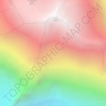
Name: Alaska Range topographic map, elevation, terrain.

Location: Alaska Range, Denali Borough, Alaska, United States (63.05995 -151.00805 63.06005 -151.00795)

Average elevation: 5,076 m

Minimum elevation: 3,471 m

Maximum elevation: 6,170 m

Other topographic maps

Click on a map to view its topography, its elevation and its terrain.
Anderson

United States > Alaska > Denali Borough

Average elevation: 171 m

Cantwell

United States > Alaska > Denali Borough

Average elevation: 1,104 m

Foraker Glacier

United States > Alaska > Denali Borough

Average elevation: 2,100 m

Denali Park

United States > Alaska > Denali Borough

Average elevation: 1,050 m

Anderson

United States > Alaska > Denali Borough

Average elevation: 171 m

Cantwell

United States > Alaska > Denali Borough

Average elevation: 1,104 m

Cantwell

United States > Alaska > Denali Borough

Average elevation: 1,104 m

Gear up for your next adventure:

🎽Hiking Clothing - Breathable clothing for hiking
📟Satellite Messengers - Two-way satellite communication to stay in touch beyond the cellular grid
🦶Orthotic Hiking Insoles - Extra arch support for long-distance topographic treks
☀️Portable Solar Chargers - High-efficiency panels to hang on your backpack while walking
🌧️Rain Jackets - Waterproof jackets for hiking

As an Amazon Associate, this site earns from qualifying purchases at no extra cost to you.