
Thank you for supporting this site ❤️
Make a donation
Make a donation
Gear up for your next adventure:
As an Amazon Associate, this site earns from qualifying purchases at no extra cost to you.
Aldeire topographic map
Click on the map to display elevation.
Thank you for supporting this site ❤️
Make a donation
Make a donation
Gear up for your next adventure:
As an Amazon Associate, this site earns from qualifying purchases at no extra cost to you.
About this map
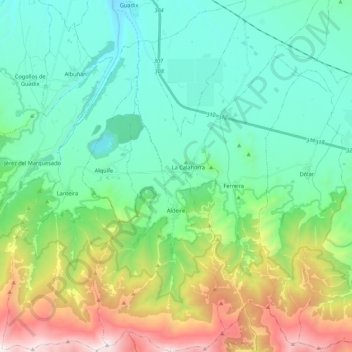
Name: Aldeire topographic map, elevation, terrain.
Location: Aldeire, Partido Judicial de Guadix, Granada, Andalusia, Spain (37.09095 -3.12235 37.26292 -3.02854)
Average elevation: 1,449 m
Minimum elevation: 966 m
Maximum elevation: 2,798 m
Thank you for supporting this site ❤️
Make a donation
Make a donation
Gear up for your next adventure:
As an Amazon Associate, this site earns from qualifying purchases at no extra cost to you.
Other topographic maps
Click on a map to view its topography, its elevation and its terrain.
Iglesia de Nuestra Señora Gracia
Spain > Andalusia > Partido Judicial de Guadix > Guadix
Average elevation: 959 m