
Snøhetta topographic map
Interactive map
Click on the map to display elevation.
About this map
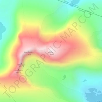
Name: Snøhetta topographic map, elevation, terrain.
Location: Snøhetta, Dovre, Innlandet, Norway (62.31981 9.26778 62.31991 9.26788)
Average elevation: 1,913 m
Minimum elevation: 1,630 m
Maximum elevation: 2,285 m
Snøhetta is the highest mountain in the Dovrefjell mountain range in Norway. At 2,286 metres (7,500 ft), it is the highest mountain in Norway outside the Jotunheimen range, making it the 24th highest peak in Norway, based on a 30-metre (98 ft) topographic prominence cutoff. At 1,675 metres (5,495 ft), its topographic prominence is the third highest in Norway.
Other topographic maps
Click on a map to view its topography, its elevation and its terrain.
Li
Norway > Innlandet > Skammestein
Li, Skammestein, Øystre Slidre, Innlandet, 2950, Norway
Average elevation: 774 m
Scandinavian Mountains
Scandinavian Mountains, Lom, Innlandet, Norway
Average elevation: 2,050 m
Fregn naturreservat
Fregn naturreservat, Trysil, Innlandet, Norway
Average elevation: 673 m
Viewpoint Snøhetta
Viewpoint Snøhetta, Vålåsjøhøvegen, Dovre, Innlandet, 2661, Norway
Average elevation: 1,157 m
Beitostølen
Beitostølen, Øystre Slidre, Innlandet, 2953, Norway
Average elevation: 914 m