
Schwytz topographic map
Interactive map
Click on the map to display elevation.
About this map
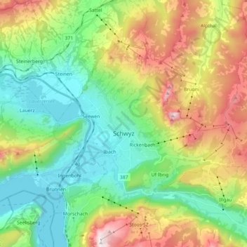
Name: Schwytz topographic map, elevation, terrain.
Location: Schwytz, Schwyz, Suisse (46.98515 8.60322 47.06642 8.77889)
Average elevation: 934 m
Minimum elevation: 420 m
Maximum elevation: 1,912 m
Schwytz se situe à 516 mètres d’altitude (place principale), au pied des deux Mythen (Grand-Mythen, 1 899 m et Petit-Mythen, 1 811 m), entre le lac de Lauerz et le lac des Quatre-Cantons.
Other topographic maps
Click on a map to view its topography, its elevation and its terrain.
Rickenbach
Suisse > Schwyz > Schwyz > Schwytz
Rickenbach, Schwytz, Schwyz, 6432, Suisse
Average elevation: 751 m