
Δήμος Νέστου topographic map
Interactive map
Click on the map to display elevation.
About this map
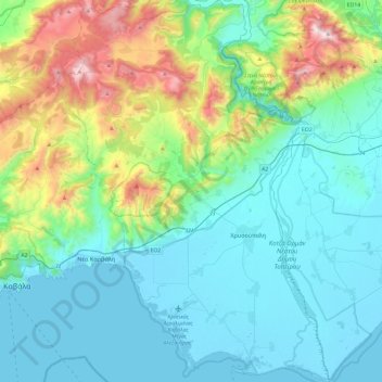
Name: Δήμος Νέστου topographic map, elevation, terrain.
Average elevation: 292 m
Minimum elevation: -3 m
Maximum elevation: 1,384 m
Other topographic maps
Click on a map to view its topography, its elevation and its terrain.
Perni
Grèce > Macédoine-Thrace > Περιφερειακή Ενότητα Καβάλας > Perni
Perni, Δήμος Νέστου, Περιφερειακή Ενότητα Καβάλας, Macédoine-Orientale-et-Thrace, Macédoine-Thrace, 64200, Grèce
Average elevation: 122 m