
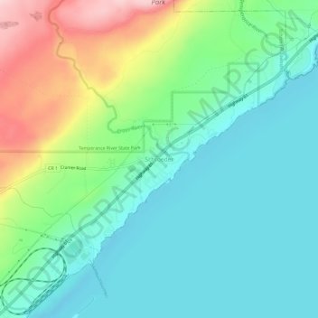
Schroeder topographic map
Interactive map
Click on the map to display elevation.
About this map
Name: Schroeder topographic map, elevation, terrain.
Average elevation: 235 m
Minimum elevation: 169 m
Maximum elevation: 399 m
Other topographic maps
Click on a map to view its topography, its elevation and its terrain.
Grand Marais
United States > Minnesota > Cook County
Grand Marais, Cook County, Minnesota, United States
Average elevation: 280 m
Magic Lake
United States > Minnesota > Cook County
Magic Lake, Schroeder Township, Cook County, Minnesota, United States
Average elevation: 564 m
Ptarmigan Lake
United States > Minnesota > Cook County
Ptarmigan Lake, West Cook, Cook County, Minnesota, United States
Average elevation: 612 m
Lutsen
United States > Minnesota > Cook County
Lutsen, Lutsen Township, Cook County, Minnesota, 55612, United States
Average elevation: 225 m
Cherokee Lake
United States > Minnesota > Cook County
Cherokee Lake, Cook County, Minnesota, United States
Average elevation: 565 m
Olso Lake
United States > Minnesota > Cook County
Olso Lake, Cook County, Minnesota, United States
Average elevation: 544 m
Hovland
United States > Minnesota > Cook County
Hovland, East Cook, Cook County, Minnesota, 56606, United States
Average elevation: 226 m
Ball Club Lake
United States > Minnesota > Cook County
Ball Club Lake, Cook County, Minnesota, United States
Average elevation: 610 m
Tofte
United States > Minnesota > Cook County
Tofte, Tofte Township, Cook County, Minnesota, 55613, United States
Average elevation: 223 m
Flour Lake
United States > Minnesota > Cook County
Flour Lake, Cook County, Minnesota, United States
Average elevation: 535 m
Grand Portage
United States > Minnesota > Cook County
Grand Portage, Cook County, Minnesota, 55605, United States
Average elevation: 257 m
Grand Portage National Monument
United States > Minnesota > Cook County
Grand Portage National Monument, Cook County, Minnesota, 55605, United States
Average elevation: 314 m
Eagle Mountain
United States > Minnesota > Cook County
Eagle Mountain, Cook County, Minnesota, United States
Average elevation: 596 m
Chippewa City
United States > Minnesota > Cook County > Chippewa City
Chippewa City, Cook County, Minnesota, United States
Average elevation: 238 m
Potato Lake
United States > Minnesota > Cook County
Potato Lake, East Cook, Cook County, Minnesota, United States
Average elevation: 621 m