Geolocate

West Point topographic map

Click on the map to display elevation.

About this map

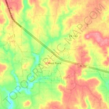
Name: West Point topographic map, elevation, terrain.

Location: West Point, Cullman County, Alabama, United States (34.22313 -86.99616 34.26476 -86.91739)

Average elevation: 284 m

Minimum elevation: 234 m

Maximum elevation: 324 m

Other topographic maps

Click on a map to view its topography, its elevation and its terrain.

Duck River

United States > Alabama > Cullman County

Average elevation: 235 m

Trimble

United States > Alabama > Cullman County

Average elevation: 185 m

Arkadelphia

United States > Alabama > Cullman County

Average elevation: 129 m

Crane Hill

United States > Alabama > Cullman County

Average elevation: 215 m

Hanceville

United States > Alabama > Cullman County > Hanceville

Average elevation: 178 m

Gear up for your next adventure:

🎽Hiking Clothing - Breathable clothing for hiking
🎒3L Hydration Reservoirs - Hands-free drinking to stay hydrated on steep contour climbs
🥾Hiking Gaiters - Leg protection for trails
🧥Packable Rain Jackets - Breathable waterproof layers for unpredictable mountain weather
🧺Fast-Dry Microfiber Towels - Large towels that pack down to the size of an orange

As an Amazon Associate, this site earns from qualifying purchases at no extra cost to you.