
Thank you for supporting this site ❤️
Make a donation
Make a donation
Gear up for your next adventure:
As an Amazon Associate, this site earns from qualifying purchases at no extra cost to you.
Brumholt topographic map
Click on the map to display elevation.
Thank you for supporting this site ❤️
Make a donation
Make a donation
Gear up for your next adventure:
As an Amazon Associate, this site earns from qualifying purchases at no extra cost to you.
About this map
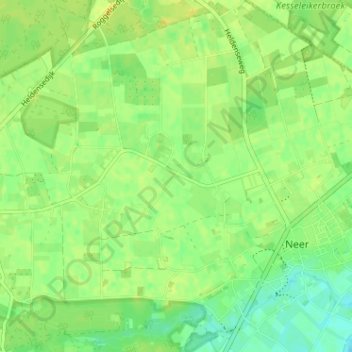
Name: Brumholt topographic map, elevation, terrain.
Location: Brumholt, Neer, Leudal, Limburg, Nederland, 6086 RE, Nederland (51.24981 5.94633 51.28981 5.98633)
Average elevation: 29 m
Minimum elevation: 17 m
Maximum elevation: 38 m
Thank you for supporting this site ❤️
Make a donation
Make a donation
Gear up for your next adventure:
As an Amazon Associate, this site earns from qualifying purchases at no extra cost to you.