
Thank you for supporting this site ❤️
Make a donation
Make a donation
Gear up for your next adventure:
As an Amazon Associate, this site earns from qualifying purchases at no extra cost to you.
Portsmouth topographic map
Click on the map to display elevation.
Thank you for supporting this site ❤️
Make a donation
Make a donation
Gear up for your next adventure:
As an Amazon Associate, this site earns from qualifying purchases at no extra cost to you.
About this map
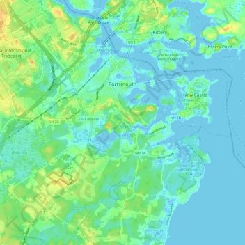
Name: Portsmouth topographic map, elevation, terrain.
Location: Portsmouth, Rockingham County, New Hampshire, United States (43.01355 -70.82300 43.09961 -70.72793)
Average elevation: 9 m
Minimum elevation: -5 m
Maximum elevation: 33 m
Thank you for supporting this site ❤️
Make a donation
Make a donation
Gear up for your next adventure:
As an Amazon Associate, this site earns from qualifying purchases at no extra cost to you.
Other topographic maps
Click on a map to view its topography, its elevation and its terrain.
Jenness Beach
United States > New Hampshire > Rockingham County > Rye > Rye Beach Village District
Average elevation: 5 m