Geolocate

Victoria topographic map

Click on the map to display elevation.

About this map
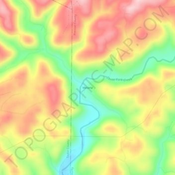
Name: Victoria topographic map, elevation, terrain.

Location: Victoria, Preston County, West Virginia, 26374, United States (39.39787 -79.90923 39.43787 -79.86923)

Average elevation: 474 m

Minimum elevation: 340 m

Maximum elevation: 591 m

Other topographic maps

Click on a map to view its topography, its elevation and its terrain.

Kingwood

United States > West Virginia > Preston County

Average elevation: 530 m

Masontown

United States > West Virginia > Preston County

Average elevation: 541 m

Tunnelton

United States > West Virginia > Preston County

Average elevation: 596 m

Kingwood

United States > West Virginia > Preston County

Average elevation: 530 m

Masontown

United States > West Virginia > Preston County

Average elevation: 541 m

Newburg

United States > West Virginia > Preston County

Average elevation: 451 m

Kingwood

United States > West Virginia > Preston County

Average elevation: 530 m

Gear up for your next adventure:

📚Map Reading & Navigation Guides - Master the art of interpreting topographic contours and symbols
📱Shockproof Phone Cases - Extra protection for your smartphone against drops on rocky terrain
🥾Hiking Gaiters - Leg protection for trails
🔪Camping Knives - Multi-purpose outdoor knives
🧦Hiking Socks - Comfortable socks for long hikes

As an Amazon Associate, this site earns from qualifying purchases at no extra cost to you.