Geolocate

Calayan Island topographic map

Click on the map to display elevation.

About this map

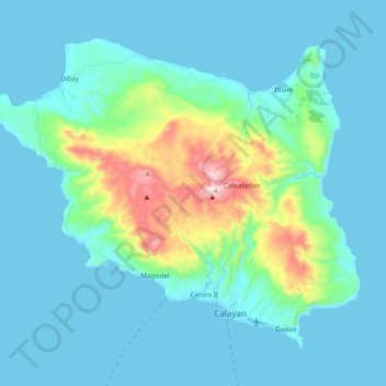
Name: Calayan Island topographic map, elevation, terrain.

Location: Calayan Island, Cagayan, Cagayan Valley, Philippines (19.24403 121.34644 19.39291 121.54240)

Average elevation: 76 m

Minimum elevation: 0 m

Maximum elevation: 505 m

Other topographic maps

Click on a map to view its topography, its elevation and its terrain.

Solana

Philippines > Cagayan

Average elevation: 33 m

Mount Camiguin

Philippines > Cagayan > Calayan

Average elevation: 289 m

Gear up for your next adventure:

📣High-Decibel Survival Whistles - Signaling tool for rescue that carries much further than a human voice
📱Shockproof Phone Cases - Extra protection for your smartphone against drops on rocky terrain
🧦Merino Wool Hiking Socks - Moisture-wicking socks to prevent blisters during long topographic surveys
🧼Clip-on Hand Sanitizer - Maintain hygiene when water for washing is scarce
🥾Hiking Boots - Durable hiking boots for trails and rough terrain

As an Amazon Associate, this site earns from qualifying purchases at no extra cost to you.