Geolocate

Greencroft topographic map

Click on the map to display elevation.

About this map

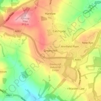
Name: Greencroft topographic map, elevation, terrain.

Location: Greencroft, Stanley, County Durham, North East, England, DH9 8NQ, United Kingdom (54.83617 -1.77079 54.87617 -1.73079)

Average elevation: 222 m

Minimum elevation: 128 m

Maximum elevation: 313 m

Other topographic maps

Click on a map to view its topography, its elevation and its terrain.

Gear up for your next adventure:

🔋Solar Power Banks - Charge your phone and GPS using the sun while deep in the bush
Altimeter Barometer Watches - Outdoor watches with built-in sensors to track altitude changes and weather shifts
🦶Orthotic Hiking Insoles - Extra arch support for long-distance topographic treks
Ultralight Solo Tents - Compact shelters for multi-day topographic surveying expeditions
🦟Insect Repellent - Protection against insects

As an Amazon Associate, this site earns from qualifying purchases at no extra cost to you.