
Make a donation
Gear up for your next adventure:
As an Amazon Associate, this site earns from qualifying purchases at no extra cost to you.
Hesse topographic map
Click on the map to display elevation.
Make a donation
Gear up for your next adventure:
As an Amazon Associate, this site earns from qualifying purchases at no extra cost to you.
Hesse
The longest rivers in Hesse are the Eder and moreover its distributary the Fulda draining most of the north, the Lahn in the centre-west and, as to those navigable by large vessels, the Main and very broad Rhine in the south. The countryside is hilly and the topographical map, inset, names 14 short, low to medium-height mountain ranges including the Rhön, the Westerwald, the Taunus, the Vogelsberg, the Knüll and the Spessart. The notable range forming the southern taper of Hesse (shared with a narrowing of the Ried, the Rhine's eastern plain) and briefly spanning the middle Neckar valley which begins directly east of Heidelberg (thus also in Baden-Württemberg) is the Odenwald. Forming a mid-eastern tiny projection into mostly Thuringia is the uppermost part of the Ulster, commanding the west valley side of which is the Hessian highest point, Wasserkuppe at 950m above sea level – in the Rhön.
Make a donation
Gear up for your next adventure:
As an Amazon Associate, this site earns from qualifying purchases at no extra cost to you.
About this map
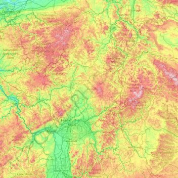
Name: Hesse topographic map, elevation, terrain.
Location: Hesse, Germany (49.39527 7.77247 51.65779 10.23641)
Average elevation: 313 m
Minimum elevation: 47 m
Maximum elevation: 973 m
Make a donation
Gear up for your next adventure:
As an Amazon Associate, this site earns from qualifying purchases at no extra cost to you.
Other topographic maps
Click on a map to view its topography, its elevation and its terrain.
Make a donation
Gear up for your next adventure:
As an Amazon Associate, this site earns from qualifying purchases at no extra cost to you.
Make a donation
Gear up for your next adventure:
As an Amazon Associate, this site earns from qualifying purchases at no extra cost to you.
Finkenstein
Germany > Thuringia > Landkreis Schmalkalden-Meiningen > Steinbach-Hallenberg
Average elevation: 723 m
Westerberg
Germany > Lower Saxony > Landkreis Hameln-Pyrmont > Hessisch Oldendorf
Average elevation: 183 m
Make a donation
Gear up for your next adventure:
As an Amazon Associate, this site earns from qualifying purchases at no extra cost to you.
Kogelberg
Germany > Bavaria > Landkreis Bad Tölz-Wolfratshausen > Lenggries
Average elevation: 1,020 m
Bernterode (bei Worbis)
Germany > Thuringia > Landkreis Eichsfeld > Bernterode (bei Worbis)
Average elevation: 306 m
Make a donation
Gear up for your next adventure:
As an Amazon Associate, this site earns from qualifying purchases at no extra cost to you.