
South-East topographic map
Interactive map
Click on the map to display elevation.
About this map
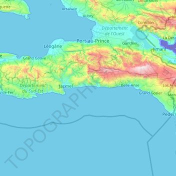
Name: South-East topographic map, elevation, terrain.
Location: South-East, Haiti (18.03147 -73.01559 18.40560 -71.72493)
Average elevation: 234 m
Minimum elevation: -43 m
Maximum elevation: 2,627 m
Other topographic maps
Click on a map to view its topography, its elevation and its terrain.
Port-au-Prince
Haiti > Département de l'Ouest > Port-au-Prince
By then, the colonial administration was convinced that a capital needed to be chosen, in order to better control the French portion of Hispaniola (Saint-Domingue). For a time, Petit-Goâve and Léogâne vied for this honor, but both were eventually ruled out for various reasons. Neither was centrally located.…
Average elevation: 376 m
Caribbean
Rainfall varies with elevation, size and water currents, such as the cool upwellings that keep the ABC islands arid. Warm, moist trade winds blow consistently from the east, creating both rain forest and semi-arid climates across the region. The tropical rainforest climates include lowland areas near the…
Average elevation: 20 m