
Mamelis topographic map
Click on the map to display elevation.
Mamelis
Mamelis ligt in het Selzerbeekdal op een hoogte van ongeveer 130 meter. Langs Mamelis stroomt de Selzerbeek die naar het oosten toe de Nederlands-Duitse grens vormt. De beek heeft naar alle waarschijnlijkheid een belangrijke rol gespeeld bij het ontstaan en de ontwikkeling van Mamelis. De beek vormt de scheiding tussen het Plateau van Bocholtz in het noordoosten en het Plateau van Vaals in het zuidwesten. Op het Plateau van Bocholtz bevindt zich het Kolmonderbosch. Vanwege de landschappelijke waarde van de omgeving is Mamelis geliefd bij toeristen en wandelaars.
About this map
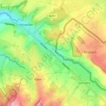
Name: Mamelis topographic map, elevation, terrain.
Location: Mamelis, Lemiers, Vaals, Limburg, Nederland, 6295 NA, Nederland (50.77756 5.95349 50.81756 5.99349)
Average elevation: 169 m
Minimum elevation: 109 m
Maximum elevation: 237 m