
Elbe topographic map
Interactive map
Click on the map to display elevation.
About this map
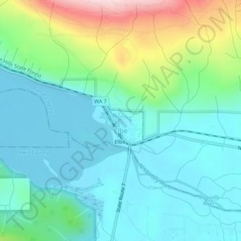
Name: Elbe topographic map, elevation, terrain.
Location: Elbe, Pierce County, Washington, Verenigde Staten (46.76304 -122.19781 46.76848 -122.18991)
Average elevation: 439 m
Minimum elevation: 357 m
Maximum elevation: 695 m
Other topographic maps
Click on a map to view its topography, its elevation and its terrain.
Little Tahoma
Verenigde Staten > Washington > Pierce County
Little Tahoma, Pierce County, Washington, Verenigde Staten
Average elevation: 2,809 m
Mount Rainier
Verenigde Staten > Washington > Pierce County
Mount Rainier, Pierce County, Washington, Verenigde Staten
Average elevation: 3,912 m