
Lower Normandy topographic map
Interactive map
Click on the map to display elevation.
About this map
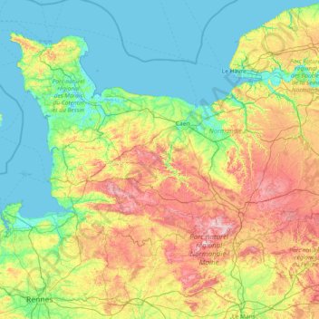
Name: Lower Normandy topographic map, elevation, terrain.
Location: Lower Normandy, Metropolitan France, France (48.17939 -1.95506 49.72801 0.97661)
Average elevation: 93 m
Minimum elevation: -2 m
Maximum elevation: 416 m
Other topographic maps
Click on a map to view its topography, its elevation and its terrain.
Orange
France > Provence-Alpes-Côte d'Azur > Vaucluse
Orange, Carpentras, Vaucluse, Provence-Alpes-Côte d'Azur, Metropolitan France, 84100, France
Average elevation: 50 m
Prat
France > Brittany > Côtes-d'Armor
Prat, Lannion, Côtes-d'Armor, Brittany, Metropolitan France, 22140, France
Average elevation: 86 m
Thônes
France > Auvergne-Rhône-Alpes > Upper Savoy
Thônes, Annecy, Upper Savoy, Auvergne-Rhône-Alpes, Metropolitan France, 74230, France
Average elevation: 1,181 m
Saint-Cirq
France > Nouvelle-Aquitaine > Dordogne > Les Eyzies
Saint-Cirq, Les Eyzies, Sarlat-la-Canéda, Dordogne, Nouvelle-Aquitaine, Metropolitan France, France
Average elevation: 139 m
Les Constants
France > Provence-Alpes-Côte d'Azur > Vaucluse > Bédoin
Les Constants, Bédoin, Carpentras, Vaucluse, Provence-Alpes-Côte d'Azur, Metropolitan France, 84410, France
Average elevation: 529 m
Courchevel
France > Auvergne-Rhône-Alpes > Savoy
Courchevel, Albertville, Savoy, Auvergne-Rhône-Alpes, Metropolitan France, 73120, France
Average elevation: 1,880 m
Montbrehain
France > Hauts-de-France > Aisne
Montbrehain, Saint-Quentin, Aisne, Hauts-de-France, Metropolitan France, 02110, France
Average elevation: 137 m
Biaches
France > Hauts-de-France > Somme
Biaches, Péronne, Somme, Hauts-de-France, Metropolitan France, 80200, France
Average elevation: 69 m
Perthes
France > Ile-de-France > Seine-et-Marne
Perthes, Fontainebleau, Seine-et-Marne, Ile-de-France, Metropolitan France, 77930, France
Average elevation: 76 m
Upper Savoy
Upper Savoy, Auvergne-Rhône-Alpes, Metropolitan France, France
Average elevation: 1,032 m
Chailly-en-Bière
France > Ile-de-France > Seine-et-Marne
Chailly-en-Bière, Fontainebleau, Seine-et-Marne, Ile-de-France, Metropolitan France, 77930, France
Average elevation: 83 m
Marseille
France > Provence-Alpes-Côte d'Azur > Bouches-du-Rhône
Marseille, Bouches-du-Rhône, Provence-Alpes-Côte d'Azur, Metropolitan France, 13000, France
Average elevation: 94 m
Le Croizet Chevalier
France > Nouvelle-Aquitaine > Creuse > Lupersat
Le Croizet Chevalier, Lupersat, Aubusson, Creuse, Nouvelle-Aquitaine, Metropolitan France, 23190, France
Average elevation: 535 m
Château
France > Bourgogne – Franche-Comté > Saône-et-Loire
Château, Mâcon, Saône-et-Loire, Bourgogne – Franche-Comté, Metropolitan France, 71250, France
Average elevation: 391 m
Bardouville
France > Normandy > Seine-Maritime
Bardouville, Rouen, Seine-Maritime, Normandy, Metropolitan France, 76480, France
Average elevation: 25 m
Les Vaillons
France > Bourgogne – Franche-Comté > Yonne > Chablis
Les Vaillons, Chablis, Auxerre, Yonne, Bourgogne – Franche-Comté, Metropolitan France, 89800, France
Average elevation: 205 m
Dalby
France > Pays de la Loire > Loire-Atlantique > Nantes
Dalby, Malakoff - Saint-Donatien, Nantes, Loire-Atlantique, Pays de la Loire, Metropolitan France, France
Average elevation: 14 m
Maligny
France > Bourgogne – Franche-Comté > Côte-d'Or
Maligny, Beaune, Côte-d'Or, Bourgogne – Franche-Comté, Metropolitan France, 21230, France
Average elevation: 391 m
Mont Sainte-Odile
France > Grand Est > Bas-Rhin > Ottrott
Mont Sainte-Odile, Ottrott, Molsheim, Bas-Rhin, Grand Est, Metropolitan France, 67530, France
Average elevation: 599 m
Pozières
France > Hauts-de-France > Somme
Pozières, Péronne, Somme, Hauts-de-France, Metropolitan France, 80300, France
Average elevation: 144 m
Moffans-et-Vacheresse
France > Bourgogne – Franche-Comté > Haute-Saône
Moffans-et-Vacheresse, Lure, Haute-Saône, Bourgogne – Franche-Comté, Metropolitan France, 70200, France
Average elevation: 316 m
Savoy
Savoy, Auvergne-Rhône-Alpes, Metropolitan France, France
Average elevation: 1,514 m
Yonne
France > Bourgogne-Franche-Comté
Yonne, Bourgogne-Franche-Comté, Metropolitan France, France
Average elevation: 207 m
Troisvilles
France > Hauts-de-France > Nord
Troisvilles, Cambrai, Nord, Hauts-de-France, Metropolitan France, 59980, France
Average elevation: 132 m
Caudry
France > Hauts-de-France > Nord
Caudry, Cambrai, Nord, Hauts-de-France, Metropolitan France, 59540, France
Average elevation: 120 m
Le Causé
France > Occitania > Tarn-et-Garonne
Le Causé, Castelsarrasin, Tarn-et-Garonne, Occitania, Metropolitan France, 82500, France
Average elevation: 186 m
Le Cannet
France > Provence-Alpes-Côte d'Azur > Maritime Alps
Le Cannet, Grasse, Maritime Alps, Provence-Alpes-Côte d'Azur, Metropolitan France, 06110, France
Average elevation: 124 m
Villecomtal-sur-Arros
Villecomtal-sur-Arros, Mirande, Gers, Occitania, Metropolitan France, 32730, France
Average elevation: 206 m
Saint-Just-Chaleyssin
France > Auvergne-Rhône-Alpes > Isère
Saint-Just-Chaleyssin, Vienne, Isère, Auvergne-Rhône-Alpes, Metropolitan France, 38540, France
Average elevation: 285 m
Les Angles-sur-Corrèze
France > Nouvelle-Aquitaine > Corrèze
Les Angles-sur-Corrèze, Tulle, Corrèze, Nouvelle-Aquitaine, Metropolitan France, 19000, France
Average elevation: 330 m
La Pairie
France > Nouvelle-Aquitaine > Charente > Manot
La Pairie, Manot, Confolens, Charente, Nouvelle-Aquitaine, Metropolitan France, 16500, France
Average elevation: 188 m
Charente-Maritime
Charente-Maritime, Nouvelle-Aquitaine, Metropolitan France, France
Average elevation: 39 m
Porta
France > Occitania > Pyrénées-Orientales
Porta, Prades, Pyrénées-Orientales, Occitania, Metropolitan France, 66760, France
Average elevation: 2,089 m
Perpignan
France > Occitania > Pyrénées-Orientales
Perpignan, Pyrénées-Orientales, Occitania, Metropolitan France, France
Average elevation: 38 m
Saint-Genest-Malifaux
France > Auvergne-Rhône-Alpes > Loire
Saint-Genest-Malifaux, Saint-Étienne, Loire, Auvergne-Rhône-Alpes, Metropolitan France, 42660, France
Average elevation: 959 m
Pierrefitte-Nestalas
France > Occitania > Hautes Pyrenees
Pierrefitte-Nestalas, Argelès-Gazost, Hautes Pyrenees, Occitania, Metropolitan France, 65260, France
Average elevation: 601 m
Champagne crayeuse
Champagne crayeuse, Grand Est, Metropolitan France, France
Average elevation: 163 m
Cavan
France > Brittany > Côtes-d'Armor
Cavan, Lannion, Côtes-d'Armor, Brittany, Metropolitan France, 22140, France
Average elevation: 88 m
Bouhy
France > Bourgogne-Franche-Comté > Nièvre
Bouhy, Cosne-Cours-sur-Loire, Nièvre, Bourgogne-Franche-Comté, Metropolitan France, 58310, France
Average elevation: 271 m
Versailles
France > Ile-de-France > Yvelines
Versailles, Yvelines, Ile-de-France, Metropolitan France, 78000, France
Average elevation: 142 m
Pukapuka
France > French Polynesia > Pukapuka
Pukapuka, Tuamotu-Gambier, French Polynesia, 98774, France
Average elevation: 2 m
Lifou
France > Loyalty Islands Province
Lifou, Loyalty Islands Province, New Caledonia, 98820, France
Average elevation: 16 m
Déziwad island
Déziwad island, La Désirade, Pointe-à-Pitre, Guadeloupe, 97127, France
Average elevation: 21 m
Ouvéa
France > Loyalty Islands Province
Ouvéa, Loyalty Islands Province, New Caledonia, France
Average elevation: 1 m