
Yonne topographic map
Interactive map
Click on the map to display elevation.
Yonne
The geology of the department is complex with concentric rings of granite, Jurassic, Cretaceous and Tertiary rocks, and layers of sedimentary rocks. The terrain is mostly a low-lying plateau used for agriculture. The southwestern part is the Puisaye, which has a higher elevation and is more wooded. To the centre and east, the land inclines to the northwest where the higher land of the Tonnerrois region lies. To the east the rock is mostly limestone. The Auxerrois region is renowned for the grapes grown here, which are used in the production of Chablis wine. To the south lies the mountainous massif of Morvan, the highest parts of which are in the neighbouring department of Nièvre. The department has some forested areas but is mainly used for pasture or cultivated for wheat.
About this map
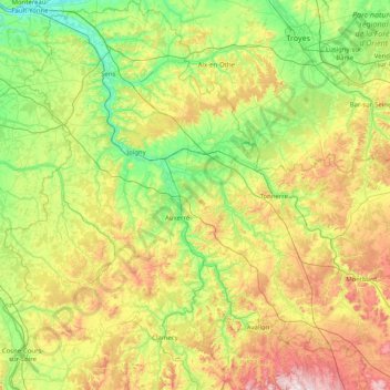
Name: Yonne topographic map, elevation, terrain.
Location: Yonne, Bourgogne – Franche-Comté, Metropolitan France, France (47.31036 2.84849 48.40006 4.34007)
Average elevation: 207 m
Minimum elevation: 45 m
Maximum elevation: 623 m
Other topographic maps
Click on a map to view its topography, its elevation and its terrain.
Saint-Valère
France > Bourgogne – Franche-Comté > Haute-Saône > Port-sur-Saône
Average elevation: 245 m
Verdin
France > Bourgogne – Franche-Comté > Saône-et-Loire > Montagny-près-Louhans
Average elevation: 199 m
Le Potin
France > Bourgogne – Franche-Comté > Nièvre > Châteauneuf-Val-de-Bargis
Average elevation: 300 m
Château d'Estours
France > Bourgogne – Franche-Comté > Saône-et-Loire > Crêches-sur-Saône > Estours
Average elevation: 183 m
Jardins de l'Hôtel du Département
France > Bourgogne – Franche-Comté > Jura > Lons-le-Saunier
Average elevation: 299 m
Le Reux
France > Bourgogne – Franche-Comté > Nièvre > Saint-Honoré-les-Bains > Tussy
Average elevation: 354 m
Le Tertre
France > Bourgogne – Franche-Comté > Haute-Saône > Amont-et-Effreney
Average elevation: 504 m
Bierre en Morvan
France > Bourgogne – Franche-Comté > Côte-d'Or > La Roche-en-Brenil
Average elevation: 385 m
L'Enclose
France > Bourgogne – Franche-Comté > Haute-Saône > Servance-Miellin
Average elevation: 566 m
La Croix
France > Bourgogne – Franche-Comté > Saône-et-Loire > Saint-Sernin-du-Bois
Average elevation: 445 m
Abbaye en Grandvaux
France > Bourgogne – Franche-Comté > Jura > Grande-Rivière-Château
Average elevation: 956 m
La Vieille Voie
France > Bourgogne – Franche-Comté > Haute-Saône > Corravillers
Average elevation: 593 m