
Loriga topographic map
Interactive map
Click on the map to display elevation.
About this map
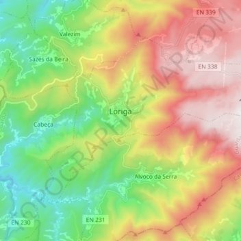
Name: Loriga topographic map, elevation, terrain.
Location: Loriga, Seia, Guarda, Portugal (40.28310 -7.73700 40.35783 -7.59530)
Average elevation: 1,016 m
Minimum elevation: 325 m
Maximum elevation: 1,938 m
Other topographic maps
Click on a map to view its topography, its elevation and its terrain.
Serra da Estrela
Serra da Estrela, Seia, Guarda, Portugal
Average elevation: 1,825 m