
Cúcuta topographic map
Interactive map
Click on the map to display elevation.
About this map
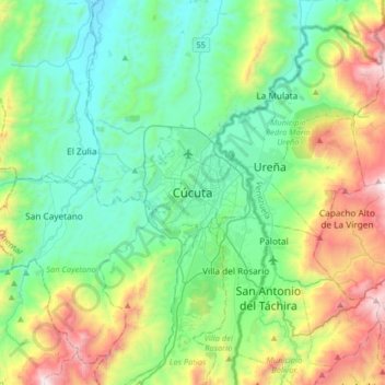
Name: Cúcuta topographic map, elevation, terrain.
Location: Cúcuta, Norte de Santander, 047, Colombia (7.73715 -72.66804 8.05715 -72.34804)
Average elevation: 575 m
Minimum elevation: 128 m
Maximum elevation: 1,786 m
Other topographic maps
Click on a map to view its topography, its elevation and its terrain.
Los olivos
Colombia > Norte de Santander > Cúcuta
Los olivos, Cúcuta, Norte de Santander, 540013, Colombia
Average elevation: 287 m