
Make a donation
Gear up for your next adventure:
As an Amazon Associate, this site earns from qualifying purchases at no extra cost to you.
New London County topographic map
Click on the map to display elevation.
Make a donation
Gear up for your next adventure:
As an Amazon Associate, this site earns from qualifying purchases at no extra cost to you.
About this map
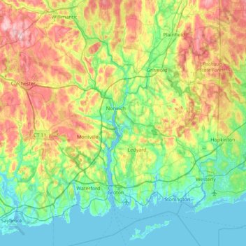
Name: New London County topographic map, elevation, terrain.
Location: New London County, Connecticut, United States (41.27132 -72.46677 41.71441 -71.78765)
Average elevation: 75 m
Minimum elevation: -3 m
Maximum elevation: 252 m
Make a donation
Gear up for your next adventure:
As an Amazon Associate, this site earns from qualifying purchases at no extra cost to you.
Other topographic maps
Click on a map to view its topography, its elevation and its terrain.
Mianus
United States > Connecticut > Western Connecticut Planning Region > Greenwich
Average elevation: 23 m
Nut Plains
United States > Connecticut > South Central Connecticut Planning Region > Guilford
Average elevation: 35 m
Make a donation
Gear up for your next adventure:
As an Amazon Associate, this site earns from qualifying purchases at no extra cost to you.
King Street
United States > Connecticut > Western Connecticut Planning Region > Danbury
Average elevation: 237 m
Apple Hill
United States > Connecticut > Northwest Hills Planning Region > Morris
Average elevation: 297 m
Sea Bluff
United States > Connecticut > South Central Connecticut Planning Region > West Haven > West Shore
Average elevation: 14 m
Make a donation
Gear up for your next adventure:
As an Amazon Associate, this site earns from qualifying purchases at no extra cost to you.
Johnsonville
United States > Connecticut > Lower Connecticut River Valley Planning Region > East Haddam
Average elevation: 58 m
West Suffield
United States > Connecticut > Capitol Planning Region > Suffield
Average elevation: 59 m
Plantsville
United States > Connecticut > Capitol Planning Region > Southington
Average elevation: 57 m
Northfield
United States > Connecticut > Northwest Hills Planning Region > Litchfield
Average elevation: 259 m
Make a donation
Gear up for your next adventure:
As an Amazon Associate, this site earns from qualifying purchases at no extra cost to you.
Huntington
United States > Connecticut > Naugatuck Valley Planning Region > Shelton
Average elevation: 111 m
Old Greenwich
United States > Connecticut > Western Connecticut Planning Region > Greenwich
Average elevation: 12 m
Hamburg
United States > Connecticut > Lower Connecticut River Valley Planning Region > Lyme
Average elevation: 49 m
Bakerville
United States > Connecticut > Northwest Hills Planning Region > New Hartford
Average elevation: 244 m
Make a donation
Gear up for your next adventure:
As an Amazon Associate, this site earns from qualifying purchases at no extra cost to you.
Haystack Mountain
United States > Connecticut > Northwest Hills Planning Region > Norfolk
Average elevation: 385 m
Laysville
United States > Connecticut > Lower Connecticut River Valley Planning Region > Old Lyme
Average elevation: 33 m
High Rock
United States > Connecticut > Southeastern Connecticut Planning Region > Waterford
Average elevation: 39 m
Fenwood
United States > Connecticut > Lower Connecticut River Valley Planning Region > Old Saybrook
Average elevation: 2 m
Make a donation
Gear up for your next adventure:
As an Amazon Associate, this site earns from qualifying purchases at no extra cost to you.
Four Corners
United States > Connecticut > Capitol Planning Region > Terramuggus
Average elevation: 143 m
Chesterfield
United States > Connecticut > Southeastern Connecticut Planning Region > Montville
Average elevation: 77 m
Hadlyme
United States > Connecticut > Lower Connecticut River Valley Planning Region > Lyme
Average elevation: 45 m
Minortown
United States > Connecticut > Naugatuck Valley Planning Region > Woodbury
Average elevation: 169 m
Make a donation
Gear up for your next adventure:
As an Amazon Associate, this site earns from qualifying purchases at no extra cost to you.
Mount Higby
United States > Connecticut > Lower Connecticut River Valley Planning Region > Middletown
Average elevation: 134 m
Marble Dale
United States > Connecticut > Northwest Hills Planning Region > Washington
Average elevation: 249 m
Washington Depot
United States > Connecticut > Northwest Hills Planning Region > Washington
Average elevation: 231 m
Killingworth Court
United States > Connecticut > South Central Connecticut Planning Region > New Haven
Average elevation: 13 m
Make a donation
Gear up for your next adventure:
As an Amazon Associate, this site earns from qualifying purchases at no extra cost to you.
Hein Trails
United States > Connecticut > South Central Connecticut Planning Region > Bethany > Davidsons Corner
Average elevation: 175 m
Nelsons Corner
United States > Connecticut > Northwest Hills Planning Region > Winchester
Average elevation: 275 m
Indian Neck
United States > Connecticut > South Central Connecticut Planning Region > Branford
Average elevation: 4 m
Nepaug
United States > Connecticut > Northwest Hills Planning Region > New Hartford
Average elevation: 222 m
Make a donation
Gear up for your next adventure:
As an Amazon Associate, this site earns from qualifying purchases at no extra cost to you.
Northford
United States > Connecticut > South Central Connecticut Planning Region > North Branford
Average elevation: 71 m
Lakeville
United States > Connecticut > Northwest Hills Planning Region > Salisbury
Average elevation: 259 m
Ansonia
United States > Connecticut > South Central Connecticut Planning Region
Average elevation: 111 m
Sandy Hook
United States > Connecticut > Western Connecticut Planning Region > Newtown
Average elevation: 113 m
Make a donation
Gear up for your next adventure:
As an Amazon Associate, this site earns from qualifying purchases at no extra cost to you.
North Franklin
United States > Connecticut > Southeastern Connecticut Planning Region
Average elevation: 103 m
East Morris
United States > Connecticut > Northwest Hills Planning Region > Morris
Average elevation: 294 m
Candlewood Lake Club
United States > Connecticut > Western Connecticut Planning Region > New Milford
Average elevation: 143 m
Make a donation
Gear up for your next adventure:
As an Amazon Associate, this site earns from qualifying purchases at no extra cost to you.
Cannondale
United States > Connecticut > Western Connecticut Planning Region > Wilton
Average elevation: 110 m
Oronoque
United States > Connecticut > Greater Bridgeport Planning Region > Stratford
Average elevation: 37 m
Southport
United States > Connecticut > Greater Bridgeport Planning Region > Fairfield
Average elevation: 11 m
Taylor Corners
United States > Connecticut > Western Connecticut Planning Region > New Fairfield
Average elevation: 226 m
Make a donation
Gear up for your next adventure:
As an Amazon Associate, this site earns from qualifying purchases at no extra cost to you.
Willington Hill
United States > Connecticut > Capitol Planning Region > Willington
Average elevation: 197 m
Wangum Village
United States > Connecticut > Northwest Hills Planning Region > Canaan
Average elevation: 235 m
Derby
United States > Connecticut > South Central Connecticut Planning Region
According to the United States Census Bureau, the town has a total area of 5.4 square miles (8.7 km2), of which, 5.0 square miles (13 km2) is land and 0.4 square miles (1.0 km2) (7.41%) is water. The city is home to the 417 acres (0.652 sq mi) Osbornedale State Park. Derby is divided into two main sections by…
Average elevation: 79 m
Make a donation
Gear up for your next adventure:
As an Amazon Associate, this site earns from qualifying purchases at no extra cost to you.
Winnipauk
United States > Connecticut > Western Connecticut Planning Region > Norwalk
Average elevation: 51 m
West Norwalk
United States > Connecticut > Western Connecticut Planning Region > Norwalk
Average elevation: 50 m
Flanders
United States > Connecticut > Southeastern Connecticut Planning Region > East Lyme
Average elevation: 43 m
Godfrey Corner
United States > Connecticut > Western Connecticut Planning Region > Weston
Average elevation: 110 m
Make a donation
Gear up for your next adventure:
As an Amazon Associate, this site earns from qualifying purchases at no extra cost to you.
Manitock Spring
United States > Connecticut > Southeastern Connecticut Planning Region > Waterford
Average elevation: 26 m
Pleasant Valley
United States > Connecticut > Northwest Hills Planning Region > Barkhamsted
Average elevation: 192 m
Skinnerville
United States > Connecticut > Lower Connecticut River Valley Planning Region > East Hampton
Average elevation: 131 m
Make a donation
Gear up for your next adventure:
As an Amazon Associate, this site earns from qualifying purchases at no extra cost to you.
Griswoldville
United States > Connecticut > Capitol Planning Region > Wethersfield
Average elevation: 34 m
Quiambaug
United States > Connecticut > Southeastern Connecticut Planning Region > Mystic
Average elevation: 8 m
Killingly Center
United States > Connecticut > Northeastern Connecticut Planning Region > Killingly > Dayville
Average elevation: 109 m
Oakdale
United States > Connecticut > Southeastern Connecticut Planning Region > Montville
Average elevation: 141 m
Make a donation
Gear up for your next adventure:
As an Amazon Associate, this site earns from qualifying purchases at no extra cost to you.
Momauguin
United States > Connecticut > South Central Connecticut Planning Region > East Haven
Average elevation: 3 m
Austrailia Beach
United States > Connecticut > Southeastern Connecticut Planning Region > Mystic
Average elevation: 19 m
Jordan Village
United States > Connecticut > Southeastern Connecticut Planning Region > Waterford
Average elevation: 27 m
Make a donation
Gear up for your next adventure:
As an Amazon Associate, this site earns from qualifying purchases at no extra cost to you.
Brockway
United States > Connecticut > Lower Connecticut River Valley Planning Region > Lyme
Average elevation: 47 m
Giants Neck
United States > Connecticut > Southeastern Connecticut Planning Region > East Lyme
Average elevation: 9 m
Drakeville
United States > Connecticut > Northwest Hills Planning Region > Torrington
Average elevation: 309 m
North Mianus
United States > Connecticut > Western Connecticut Planning Region > Greenwich
Average elevation: 32 m
Make a donation
Gear up for your next adventure:
As an Amazon Associate, this site earns from qualifying purchases at no extra cost to you.
Saugatuck
United States > Connecticut > Western Connecticut Planning Region > Westport
Average elevation: 15 m
Indian Cave
United States > Connecticut > South Central Connecticut Planning Region > Guilford
Average elevation: 25 m
Five Points
United States > Connecticut > Western Connecticut Planning Region > Redding Ridge
Average elevation: 185 m
Make a donation
Gear up for your next adventure:
As an Amazon Associate, this site earns from qualifying purchases at no extra cost to you.
Daniels Mill
United States > Connecticut > Western Connecticut Planning Region > New Canaan
Average elevation: 100 m
White Hills
United States > Connecticut > Naugatuck Valley Planning Region > Shelton
Average elevation: 124 m
Thomas Mountain
United States > Connecticut > Western Connecticut Planning Region > Danbury
Average elevation: 197 m
Central Village
United States > Connecticut > Northeastern Connecticut Planning Region > Plainfield
Average elevation: 69 m
Make a donation
Gear up for your next adventure:
As an Amazon Associate, this site earns from qualifying purchases at no extra cost to you.
Chaffeeville
United States > Connecticut > Capitol Planning Region > Mansfield
Average elevation: 133 m
West District
United States > Connecticut > Capitol Planning Region > Farmington
Average elevation: 92 m
Lookout
United States > Connecticut > Northwest Hills Planning Region > Goshen
Average elevation: 434 m
Talcott Mountain
United States > Connecticut > Capitol Planning Region > Bloomfield
Average elevation: 152 m
Make a donation
Gear up for your next adventure:
As an Amazon Associate, this site earns from qualifying purchases at no extra cost to you.
North Madison
United States > Connecticut > South Central Connecticut Planning Region > Madison
Average elevation: 91 m
Bartholomew Hill
United States > Connecticut > Northwest Hills Planning Region > Goshen
Average elevation: 426 m
South Wethersfield
United States > Connecticut > Capitol Planning Region > Wethersfield > Griswoldville
Average elevation: 22 m
Make a donation
Gear up for your next adventure:
As an Amazon Associate, this site earns from qualifying purchases at no extra cost to you.
Fort Trumbull
United States > Connecticut > South Central Connecticut Planning Region > Milford
Average elevation: 7 m
Germantown
United States > Connecticut > Western Connecticut Planning Region > Danbury
Average elevation: 121 m
Bishop's Corner
United States > Connecticut > Capitol Planning Region > West Hartford
Average elevation: 47 m
Pinneys Corners
United States > Connecticut > Western Connecticut Planning Region > New Canaan
Average elevation: 143 m
Make a donation
Gear up for your next adventure:
As an Amazon Associate, this site earns from qualifying purchases at no extra cost to you.
Branford Court
United States > Connecticut > South Central Connecticut Planning Region > New Haven
Average elevation: 13 m
Canaan Valley
United States > Connecticut > Northwest Hills Planning Region > North Canaan
Average elevation: 293 m
Buckingham
United States > Connecticut > Capitol Planning Region > Glastonbury
Average elevation: 131 m
Riverside
United States > Connecticut > Western Connecticut Planning Region > Greenwich > Old Greenwich
Average elevation: 13 m
Make a donation
Gear up for your next adventure:
As an Amazon Associate, this site earns from qualifying purchases at no extra cost to you.
North Coventry
United States > Connecticut > Capitol Planning Region > Coventry
Average elevation: 195 m
Beaver Brook
United States > Connecticut > Western Connecticut Planning Region > Danbury
Average elevation: 119 m
West Shore
United States > Connecticut > South Central Connecticut Planning Region > West Haven
Average elevation: 9 m
Make a donation
Gear up for your next adventure:
As an Amazon Associate, this site earns from qualifying purchases at no extra cost to you.
North Haven Bridge
United States > Connecticut > South Central Connecticut Planning Region > North Haven
Average elevation: 22 m
Lake Whitney
United States > Connecticut > South Central Connecticut Planning Region > Hamden > Whitneyville
Average elevation: 25 m
South End Point
United States > Connecticut > South Central Connecticut Planning Region > East Haven > Momauguin
Average elevation: 2 m
Talcott Mountain
United States > Connecticut > Capitol Planning Region > Bloomfield
Average elevation: 152 m
Make a donation
Gear up for your next adventure:
As an Amazon Associate, this site earns from qualifying purchases at no extra cost to you.