
Altenau topographic map
Interactive map
Click on the map to display elevation.
About this map
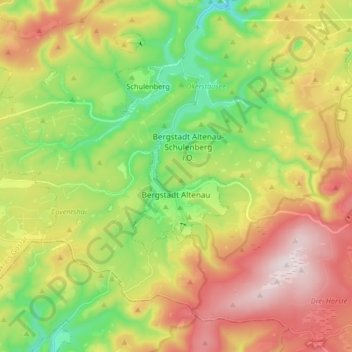
Name: Altenau topographic map, elevation, terrain.
Average elevation: 599 m
Minimum elevation: 341 m
Maximum elevation: 923 m
Other topographic maps
Click on a map to view its topography, its elevation and its terrain.
Torfhaus
Duitsland > Nedersaksen > Landkreis Goslar > Clausthal-Zellerfeld
Torfhaus, Clausthal-Zellerfeld, Landkreis Goslar, Nedersaksen, 38667, Duitsland
Average elevation: 748 m