
Make a donation
Gear up for your next adventure:
As an Amazon Associate, this site earns from qualifying purchases at no extra cost to you.
Msukaligwa topographic map
Click on the map to display elevation.
Make a donation
Gear up for your next adventure:
As an Amazon Associate, this site earns from qualifying purchases at no extra cost to you.
About this map
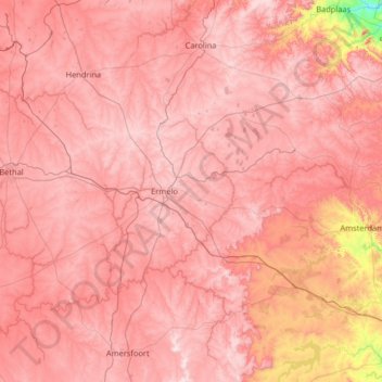
Name: Msukaligwa topographic map, elevation, terrain.
Location: Msukaligwa, Gert Sibande, Mpumalanga, South Africa (-26.85981 29.46867 -26.17069 30.76824)
Average elevation: 1,602 m
Minimum elevation: 937 m
Maximum elevation: 1,937 m
Make a donation
Gear up for your next adventure:
As an Amazon Associate, this site earns from qualifying purchases at no extra cost to you.
Other topographic maps
Click on a map to view its topography, its elevation and its terrain.
Mpuluzi
South Africa > Mpumalanga > Gert Sibande > Albert Luthuli Local Municipality
Average elevation: 1,458 m
Vygeboom Dam
South Africa > Mpumalanga > Gert Sibande > Albert Luthuli Local Municipality
Average elevation: 1,056 m
Make a donation
Gear up for your next adventure:
As an Amazon Associate, this site earns from qualifying purchases at no extra cost to you.
Wakkerstroom
South Africa > Mpumalanga > Gert Sibande > Pixley Ka Seme Local Municipality
Average elevation: 1,828 m
Standerton
South Africa > Mpumalanga > Gert Sibande > Lekwa Local Municipality
Average elevation: 1,554 m
Volksrust
South Africa > Mpumalanga > Gert Sibande > Pixley Ka Seme Local Municipality
The town was laid out in 1888 on the farms Boschpad Drift, Rooibult or Llanwarne, Verkyk and Zandfontein, and proclaimed in 1889. It lies at an elevation of 5,429 feet (1,655 m), and 4 miles (6.4 km) north of the pass through the Drakensberg known as Laing's Nek. Municipal status was attained in 1904.
Average elevation: 1,688 m
Make a donation
Gear up for your next adventure:
As an Amazon Associate, this site earns from qualifying purchases at no extra cost to you.
Piet Retief
South Africa > Mpumalanga > Gert Sibande > Mkhondo Local Municipality
Average elevation: 1,276 m
Amsterdam
South Africa > Mpumalanga > Gert Sibande > Mkhondo Local Municipality
Average elevation: 1,290 m
eLukwatini
South Africa > Mpumalanga > Gert Sibande > Albert Luthuli Local Municipality
Average elevation: 1,033 m
Thuthukani
South Africa > Mpumalanga > Gert Sibande > Lekwa Local Municipality
Average elevation: 1,586 m
Make a donation
Gear up for your next adventure:
As an Amazon Associate, this site earns from qualifying purchases at no extra cost to you.
Carolina
South Africa > Mpumalanga > Gert Sibande > Albert Luthuli Local Municipality
Average elevation: 1,675 m
Bethal
South Africa > Mpumalanga > Gert Sibande > Govan Mbeki Local Municipality
Average elevation: 1,662 m
Nazareth
South Africa > Mpumalanga > Gert Sibande > Albert Luthuli Local Municipality
Average elevation: 1,471 m
Make a donation
Gear up for your next adventure:
As an Amazon Associate, this site earns from qualifying purchases at no extra cost to you.
Grootdraai Dam
South Africa > Mpumalanga > Gert Sibande > Lekwa Local Municipality
Average elevation: 1,549 m
Mpuluzi
South Africa > Mpumalanga > Gert Sibande > Albert Luthuli Local Municipality
Average elevation: 1,458 m
Standerton
South Africa > Mpumalanga > Gert Sibande > Lekwa Local Municipality
Average elevation: 1,554 m
Make a donation
Gear up for your next adventure:
As an Amazon Associate, this site earns from qualifying purchases at no extra cost to you.
Amersfoort
South Africa > Mpumalanga > Gert Sibande > Pixley Ka Seme Local Municipality
Average elevation: 1,660 m
Balfour
South Africa > Mpumalanga > Gert Sibande > Dipaleseng Local Municipality
Average elevation: 1,636 m
Secunda
South Africa > Mpumalanga > Gert Sibande
Secunda is located at approximately 26°S latitude and 29°E longitude, at an elevation of 1,620 metres above sea level. It lies 180 kilometres from Pretoria, 135 kilometres from Johannesburg, 100 kilometres from Brakpan, 250 kilometres from Potchefstroom, 530 kilometres from Durban, and 1,530 kilometres from…
Average elevation: 1,619 m
Make a donation
Gear up for your next adventure:
As an Amazon Associate, this site earns from qualifying purchases at no extra cost to you.
eLukwatini
South Africa > Mpumalanga > Gert Sibande > Albert Luthuli Local Municipality
Average elevation: 1,033 m
Carolina
South Africa > Mpumalanga > Gert Sibande > Albert Luthuli Local Municipality
Average elevation: 1,675 m
Make a donation
Gear up for your next adventure:
As an Amazon Associate, this site earns from qualifying purchases at no extra cost to you.
Amersfoort
South Africa > Mpumalanga > Gert Sibande > Pixley Ka Seme Local Municipality
Average elevation: 1,660 m
Volksrust
South Africa > Mpumalanga > Gert Sibande > Pixley Ka Seme Local Municipality
The town was laid out in 1888 on the farms Boschpad Drift, Rooibult or Llanwarne, Verkyk and Zandfontein, and proclaimed in 1889. It lies at an elevation of 5,429 feet (1,655 m), and 4 miles (6.4 km) north of the pass through the Drakensberg known as Laing's Nek. Municipal status was attained in 1904.
Average elevation: 1,688 m
Grootdraai Dam
South Africa > Mpumalanga > Gert Sibande > Lekwa Local Municipality
Average elevation: 1,549 m
Make a donation
Gear up for your next adventure:
As an Amazon Associate, this site earns from qualifying purchases at no extra cost to you.
Blesbokspruit
South Africa > Mpumalanga > Gert Sibande > Lekwa Local Municipality
Average elevation: 1,606 m