
Make a donation
Gear up for your next adventure:
As an Amazon Associate, this site earns from qualifying purchases at no extra cost to you.
Agua Dulce topographic map
Click on the map to display elevation.
Make a donation
Gear up for your next adventure:
As an Amazon Associate, this site earns from qualifying purchases at no extra cost to you.
Agua Dulce
Agua Dulce (Spanish for "sweet water") is a census-designated place in Los Angeles County, California, United States. It lies at an elevation of 2,526 feet (770 m), northeast of Santa Clarita. The community had a population of 3,342 at the 2010 census and covers a geographic area of about 23 square miles (59 km2). The ZIP code is 91390 (shared with Green Valley and far northern Santa Clarita), and the area code is 661.
Make a donation
Gear up for your next adventure:
As an Amazon Associate, this site earns from qualifying purchases at no extra cost to you.
About this map
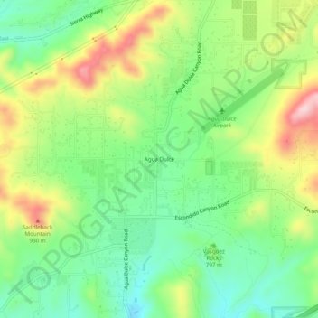
Name: Agua Dulce topographic map, elevation, terrain.
Location: Agua Dulce, California, United States (34.47638 -118.34563 34.51638 -118.30563)
Average elevation: 803 m
Minimum elevation: 694 m
Maximum elevation: 977 m
Make a donation
Gear up for your next adventure:
As an Amazon Associate, this site earns from qualifying purchases at no extra cost to you.