
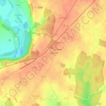
La Ferandière topographic map
Interactive map
Click on the map to display elevation.
About this map
Name: La Ferandière topographic map, elevation, terrain.
Average elevation: 129 m
Minimum elevation: 96 m
Maximum elevation: 143 m
Other topographic maps
Click on a map to view its topography, its elevation and its terrain.
Romilly-sur-Aigre
France > Centre-Val de Loire > Eure-et-Loir > Cloyes-les-Trois-Rivières
Romilly-sur-Aigre, Cloyes-les-Trois-Rivières, Châteaudun, Eure-et-Loir, Centre-Val de Loire, France métropolitaine, 28220, France
Average elevation: 118 m
Autheuil
France > Centre-Val de Loire > Eure-et-Loir > Cloyes-les-Trois-Rivières
Autheuil, Cloyes-les-Trois-Rivières, Châteaudun, Eure-et-Loir, Centre-Val de Loire, France métropolitaine, 28220, France
Average elevation: 123 m
Saint-Hilaire-sur-Yerre
France > Centre-Val de Loire > Eure-et-Loir > Cloyes-les-Trois-Rivières
Saint-Hilaire-sur-Yerre, Cloyes-les-Trois-Rivières, Châteaudun, Eure-et-Loir, Centre-Val de Loire, France métropolitaine, 28220, France
Average elevation: 135 m
Charray
France > Centre-Val de Loire > Eure-et-Loir > Cloyes-les-Trois-Rivières
Charray, Cloyes-les-Trois-Rivières, Châteaudun, Eure-et-Loir, Centre-Val de Loire, France métropolitaine, 28220, France
Average elevation: 124 m
Cloyes-sur-le-Loir
France > Centre-Val de Loire > Eure-et-Loir > Cloyes-les-Trois-Rivières
Cloyes-sur-le-Loir, Cloyes-les-Trois-Rivières, Châteaudun, Eure-et-Loir, Centre-Val de Loire, France métropolitaine, 28220, France
Average elevation: 127 m