
Make a donation
Gear up for your next adventure:
As an Amazon Associate, this site earns from qualifying purchases at no extra cost to you.
Damekow topographic map
Click on the map to display elevation.
Make a donation
Gear up for your next adventure:
As an Amazon Associate, this site earns from qualifying purchases at no extra cost to you.
About this map
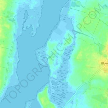
Name: Damekow topographic map, elevation, terrain.
Average elevation: 4 m
Minimum elevation: -5 m
Maximum elevation: 19 m
Make a donation
Gear up for your next adventure:
As an Amazon Associate, this site earns from qualifying purchases at no extra cost to you.
Other topographic maps
Click on a map to view its topography, its elevation and its terrain.
Farpener Stausee
Deutschland > Mecklenburg-Vorpommern > Nordwestmecklenburg > Blowatz > Alt Farpen
Die Talsperre wurde zwischen 1976 und 1978 zur landwirtschaftlichen Bewässerung errichtet. Laut mehreren Quellen wird der Farpener Bach angestaut. In den digitalen Karten des Geodatenportals MV tragen die Zuflüsse im Süden und Nordosten keine Namen und der Abfluss im Nordwesten ist als Plastbach bezeichnet,…
Average elevation: 17 m