
Cherbourg-en-Cotentin topographic map
Interactive map
Click on the map to display elevation.
About this map
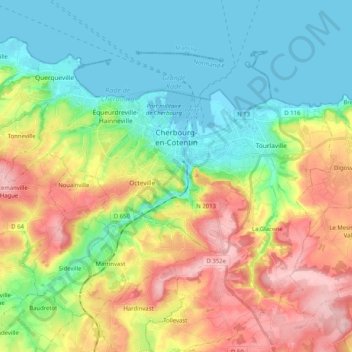
Name: Cherbourg-en-Cotentin topographic map, elevation, terrain.
Average elevation: 67 m
Minimum elevation: -3 m
Maximum elevation: 181 m
Other topographic maps
Click on a map to view its topography, its elevation and its terrain.
Cherbourg-Octeville
Frankreich > Normandie > Manche > Cherbourg-en-Cotentin
Cherbourg-Octeville, Cherbourg-en-Cotentin, Cherbourg, Manche, Normandie, Metropolitanes Frankreich, Frankreich
Average elevation: 39 m