
Amiens topographic map
Interactive map
Click on the map to display elevation.
About this map
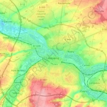
Name: Amiens topographic map, elevation, terrain.
Location: Amiens, Somme, Hauts-de-France, France métropolitaine, France (49.84684 2.22356 49.95055 2.34578)
Average elevation: 55 m
Minimum elevation: 9 m
Maximum elevation: 116 m
La superficie de la commune est de 4 946 hectares ; son altitude varie entre 14 et 106 mètres.