
Ayres topographic map
Interactive map
Click on the map to display elevation.
About this map
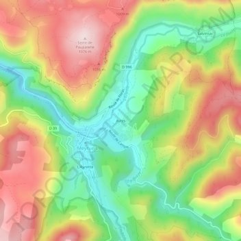
Name: Ayres topographic map, elevation, terrain.
Average elevation: 871 m
Minimum elevation: 684 m
Maximum elevation: 1,076 m
Other topographic maps
Click on a map to view its topography, its elevation and its terrain.
Château de Roquedols
France > Occitanie > Lozère > Meyrueis
Château de Roquedols, Chemin de Ferrussac, Roquedols, Meyrueis, Florac, Lozère, Occitanie, France métropolitaine, 48150, France
Average elevation: 869 m