
Hamilton topographic map
Interactive map
Click on the map to display elevation.
About this map
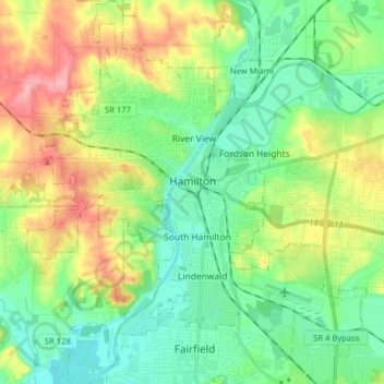
Name: Hamilton topographic map, elevation, terrain.
Average elevation: 210 m
Minimum elevation: 163 m
Maximum elevation: 303 m
Other topographic maps
Click on a map to view its topography, its elevation and its terrain.
Neilan & Pershing Park
États-Unis d'Amérique > Ohio > Hamilton
Neilan & Pershing Park, 2, Main Street Historic District, Rossville Historic District, Hamilton, Comté de Butler, Ohio, États-Unis d'Amérique
Average elevation: 191 m