
Make a donation
Gear up for your next adventure:
As an Amazon Associate, this site earns from qualifying purchases at no extra cost to you.
Albany topographic map
Click on the map to display elevation.
Make a donation
Gear up for your next adventure:
As an Amazon Associate, this site earns from qualifying purchases at no extra cost to you.
Albany
The highest natural point in Albany is a USGS benchmark near the Loudonville Reservoir off Birch Hill Road, at 378 feet (115 m) above sea level. The lowest point is sea level at the Hudson River (the average water elevation is 2 feet (0.61 m)), which is still technically an estuary at Albany and is affected by the Atlantic tide. The interior of Albany consists of rolling hills which were once part of the Albany Pine Bush, an area of pitch pine and scrub oak, and has arid, sandy soil that is a remnant of the ancient Lake Albany. Due to development, the Pine Bush has shrunk from an original 25,000 to 6,000 acres (10,100 to 2,400 ha) today. A preserve was set up by the State Legislature in 1988 and is on the city's western edge, spilling into Guilderland and Colonie; it is the only sizable inland pine barrens sand dune ecosystem in the United States, and is home to many endangered species, including the Karner Blue butterfly.
Make a donation
Gear up for your next adventure:
As an Amazon Associate, this site earns from qualifying purchases at no extra cost to you.
About this map
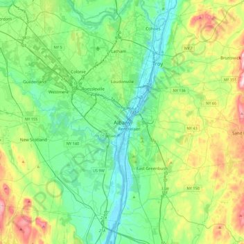
Name: Albany topographic map, elevation, terrain.
Location: Albany, Albany County, New York, 12207, United States (42.49117 -73.91497 42.81117 -73.59497)
Average elevation: 114 m
Minimum elevation: -2 m
Maximum elevation: 421 m
Make a donation
Gear up for your next adventure:
As an Amazon Associate, this site earns from qualifying purchases at no extra cost to you.